A nice Saturday ride
 When we were at the Washington County Fair a couple of weeks ago, I got a free map (thanks, Metro!) showing all the bike-friendly roads in Washington County. One of them caught my eye: the Banks-Vernonia State Trail.
The trail used to be an old railway that carried lumber in the 1920s, but was abandoned in the '70s and the state took ownership in 1990.
I found an actual PDF map for the trail on the Oregon Parks website, and we scoped out our plan. Considering I would be pulling the bike trailer with the little tyke inside, we had no intention of riding the entire 21-mile length. We would start in Vernonia and ride down the trail to the Beaver Creek Trailhead (a distance of roughly 4.5 miles), which the map said had picnic facilities and restrooms. There, we'd eat the lunch we packed and head back to the starting point.
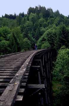
So last weekend, my family loaded the bikes onto the car and made the drive to Vernonia. Highway 47 is a beautiful, somewhat curvy drive north from Highway 26. It's a longer drive than we realized, even from the west side of Portland, but as you drive north, you can see two of the old railway trestles, as well as lots of rural countryside. (Accompanying photo of the Buxton Trestle found on the website of William L. Sullivan. I doubt if the trestle is actually accessible, despite the pedestrian in the photo.)
Little did we know that the Vernonia Friendship Jamboree is scheduled for the first weekend of August. We got to Vernonia and found that every human being -- not to mention every hot motorcycle and vintage car -- in the nearest three counties had gathered in this sleepy town that is usually home to less than 3,000 people.
After crawling through town at slower than pedestrian pace, we found that the Banks-Vernonia Trail head (Anderson Park) was also the epicenter of the Jamboree, and it was closed to vehicles. Also, there was no parking to be had. So, we decided to crawl back through town and drive to the Beaver Creek Trailhead, where we'd have lunch before hitting the trail. From there, we could follow the trail south until we ran out of pavement (about three miles), then turn back.
"Picnic facilities" turned out to be a somewhat generous description -- it meant there was one picnic table -- but we had no human competition for the table and we wolfed down lunch. As we got on the bikes, we met a couple coming from the direction we were heading, and one said to the other, "We got down here a lot faster than we did going the other direction. It must be a little bit uphill."
And they were right. It was a steady, but not steep, uphill climb to the end of the pavement (the state parks department plans to have the whole trail paved by sometime next year). The trail parallels Highway 47, so there is some highway noise, though that was probably louder than usual due to the jamboree up the road. But you rarely see the highway. Occasionally you'll see a farm or a road (be prepared to drive around roadblocks intended to keep the trail free of motor vehicles), and there are a couple of areas that have been clearcut in recent history. But there's also some lush forest, and a little bit of wildlife (nothing big -- we saw a squirrel, a small snake sunning itself on the pavement, and lots of birds).
The pavement runs out at milepost 7, so we stopped there and turned back, but I'm guessing that the prettiest part of the trail is the unpaved section, which runs for about eight miles beyond that point. That section, according to the map, crosses five rivers, and it's also the only section that doesn't follow the highway. That part is most easily accessible from the Buxton Trailhead, which is no more than a couple of miles north of the Sunset Highway.
Once we turned back, the incline worked to our advantage, and the trip back was an easy glide. We are not regular bicyclists, but we ended up going about eight miles for the day and none of us -- including our 8-year-old -- had any trouble with the ride.
Overall it was a very nice day, and I think the trail will be exceptionally beautiful once the fall leaves start changing color. We ran into no more than 10 people the entire day, so it's a very peaceful ride other than the occasional vehicle noise. If you're looking for something to do on a sunny day, this isn't a bad option.
posted by Ken @ 11:01 AM
![]()
![]()
1 Comments:
At 8/12/2006 12:40 PM, MAX Redline said…
That's quite a nice linear parkway. Last time I was there, it was gravel. It crosses one river, the Nehalem, and several smaller streams.
Post a Comment
<< Home